Perhaps in the grand tradition of naming years after the things that happen, this year should be called "the years things got paved." It would be more true to say that, starting in this past summer, parts of Bowen heretofore previously composed of gravel and potholes got a good coat of black top. It started with the sidewalks in the lower Cove and then around Christmas, the parking lot at the United Church got a coat of pavement too, and a curb and a fence to stop people backing out on to the blind corner on Miller Road. Now today, home after nearly two weeks on the road, I see that the parking lot at the Catholic Church, where the residents o Deep Bay stop to collect their mail, has had it's lakes and rivers filled in with sealed asphalt. Ah progress...
And in related "improvement" news, it seems that he Bow Mart renovations are proceeding along. The Bow-Mart was a Bowen institution, an exclusive preserve of a certain generation of island men, who each claimed a stool at the lunch bar and were served coffee and conversation until they died - some of them actually dying right there on their stools. It was the kind of place that defined an older island mentality - open and embracing of long time residents, but suspicious of newcomers, meaning anyone who had arrived in the past generation or so. That kind of thing is largely gone noe, although it survives to some extent in public meetings about zoning issues (!) but with it went a part of the island's character.
Now the Bow-Mart, under whose new ownership I cannot say, is sporting new, brighter coat of brown paint and a new deck around the outsides. It looks like it will reopen as a diner and it seems like the name s being kept and the plastic, occasionally illuminated sign on the post out front seems to be staying, a heritage marker if ever there was one.
It does seem like throw back week around here. The Queen of Capilano has finally gone for her refit - an event that usually happens every year, but didn't happen in 2006. She's off to get herself tuned up and refitted so that she doesn't take logs into her props and suffer the kinds of damage that has sidelined her the past couple of years. At any rate it means that the Bowen Queen is on duty until the beginning of April. She's a smaller and much older boat, having been built in the early 1960s, and whenever I ride her, I have a lovely sensation of actually living on an island. The Cap is nice, but she lacks the charm and inconvenience of the older boats that serve most of the inner islands. This one is rusty and cluttered, with pipes and cables exposed along the ceilings and a powerful diesal engine rumbling beneath decks. Her shabbier appearance belies the fact that she is actually a faster boat than the Cap and when the crew needs to make up time, you really feel it.
My work these days carries me far and wide and around this continent, but I am discovering that such sojourns make me eyes clearer and my heart sing more sweetly when I return here, no matter how fleetingly.
Wednesday, February 21, 2007

Thursday, January 18, 2007
Another winter blast last night. Before midnight a lot of wet snow started falling and by the time I headed down to the Cove it was about 5cms deep, hard to walk on and very wet. There were lots of branches coming down and a power outage a couple of minutes after I knocked my alarm off at 6:30am.
The Snug, however was hopping. Young Will had hooked up a generator and we enjoyed warmth and coffee huddling in the cafe.
Power outages and storms are great for me. They make things inconvienient, and that is why I moved to Bowen in the first place. It seems with the crazy weather that we should expect these things to be more and more common. I travel everywhere with my wind up flashlight now, and today, as a result of the mess everywhere I got to meet a long time islander who I had only seen in passing for six years.
So if you're thinking of moving here, remember that things move slowly in the winter, and it's a good idea to learn to enjoy that.
The Snug, however was hopping. Young Will had hooked up a generator and we enjoyed warmth and coffee huddling in the cafe.
Power outages and storms are great for me. They make things inconvienient, and that is why I moved to Bowen in the first place. It seems with the crazy weather that we should expect these things to be more and more common. I travel everywhere with my wind up flashlight now, and today, as a result of the mess everywhere I got to meet a long time islander who I had only seen in passing for six years.
So if you're thinking of moving here, remember that things move slowly in the winter, and it's a good idea to learn to enjoy that.
Not much posting lately obviously, what with christmas and a holiday on Maui during wqhich another wind storm knocked things about here.
We've had a couple of days of light snow lately and colder weather, and the water is clam and flat and even a little thick looking. Into the depths of winter, after a stormy fall.
We've had a couple of days of light snow lately and colder weather, and the water is clam and flat and even a little thick looking. Into the depths of winter, after a stormy fall.
Monday, December 18, 2006

Trees down in Crippen Park
Photo by Opa
Photo by Opa
So the third of this series of three storms has come and gone and it was a doozy.
When it landed off the west coast of Vancouver Island it was basically a hurricane and the surprise was both that it didn't let up much AND that the winds were westerly, which made it different from the southeasterlies that usually batter us. Point Atkinson had a record wind speed of 115km/h early Friday morning.
The real fun began Friday at about 3:30 am. The trees outside our place were really moving, and the wind was stronger than any I had ever felt. The strange thing was that they were blowing from behind us. We hardly ever feel a westerly wind blowing, but this one was wrecking havoc outside. Miller Road looked like someone had carpeted it with fir bows. I stood on our front porch and saw lots of lightning and watched patches of power go out in Whytecliff. We lost ou power at 3am.
The worst of the wind was over by 8am or so, but the damage had been done. There were trees down everywhere and huge damage to the power grid. The speculation was that we wouldn't have power for three or four days. We decided to use the event as a test run for earthquake preparedness. We broke out our wind up radio and cooked on the woodstove all day Friday and Saturday. Our water supply is gravity fed, so we had no trouble with water (unlike folks on wells) and we had heat and a cooking surface. I didn't even have to fire up the barbeque. In fact, other than going about our regular routines by candle light, things were surprisingly normal around here. That was, I think, in large part to our preparedness and the set up we have. It feels like we could go for four or five days without any trouble. That is what the provincial emergency preparedness program recommends for earthquake preparedness. Of course, if the house had sustained damage, we would have been camping out, but our emergency supplies are all at hand and it would have been no problem to move out of doors. All in all we fared very well.
The power came on about 7:30pm on Saturday, just as Caitlin and I were completing our black belt test in taekwondo, which we did at Cates Hill Chapel in a candle and lamp lit setting. It was a very traditional way to acheive this level in the Korean martial art and it was a very wonderful experience to have been able to do that with friends and family about in the cold and dark as we kicked, sparred and broke our way through the afternoon.
Once the power was on, we were able to see the real damage. There are trees down, and the Hydro crews were heros getting the island back on the grid by Sunday. A few plaes sustained damage from falling trees, but there were more stories of good luck than bad. We were in Vancouver today though and drove through Stanley Park and it is a mess. There are hundreds of trees down there and while not as devastated as Halifax during hurricane Juan, it's as bad as anyone has ever seen.
Bottom line is we're fine, not even a little shaken, and more confiedent tha ever about our ability to weather a bigger disaster if and when it comes.
As for what might come this week, the north Pacific weather map looks like a coache's diagram for a hockey game. There are five lows steaming towards us but we have two all-star defensemen in the form of a couple of huge high pressure zones to the southwest that might steer them north and give us some nice clear weather for Christmas. The forecast calles for more rain but stay tuned...anything could happen around here!

Monday, December 11, 2006
Winds continue to blow strong all day today. Aine and I went down to Pebbly beach to see about a report of a boat sinking there. We saw it moored offshore a little ways - pictures to follow. It looked like its bilge pump must have failed and it just took on water. The wind and waves didn't help.
We had the chimney sweeps over this morning as well. Quite a sight to see them up on the roof in the gale.
The pressure slope has been souteasterly at 7 millibars/60nm this afternoon. That's high conditions for the kinds of winds we have been getting. Ninety km gusts, big swells travelling along the long fetch of the Strait and slamming into Dorman Point and Miller's Landing. The Channel in front of our house has been chaos all day, and as the very high tide receeded, some big water piled up out there. I rode through it this evening in the ferry coming over to the mainland and we shook around coming across the westernmost reach of the fetch. Once the boat gets behind Point Atkinson, about halfway across the Channel, things flatten out considerably, although the wind is still strong.
And, to my delight this afternoon I glanced out the window at the water and saw three waterspouts heading south out of the Sound, the result of some kind of strange wind shear no doubt.
Forescast offshore continues to be harsh, with another system building huuricane force wionds ahead of another warm front. The seas out at La Perouse Bank, about 100 miles of Vancouver Island are running 8 meters tonight. Here is the forecast from that buoy:
Forecast:
Storm warning upgraded to hurricane force wind warning.
Winds west to southwest storm force 60 knots with gusts to hurricane force 80 easing to southwest 20 to 30 early this evening then to easterly 15 late this evening. Winds rising to southwest 20 to 30 overnight then to southeast gales 40 to storm force 50 Tuesday afternoon. Periods of rain. Morning fog patches. Seas near 8 metres subsiding to 5 this evening.
Outlook. Winds gale to storm force southeast veering to southwest gales.
Eighty knots is almost 150 km/h. That's a strong wind. It will ease by the time it hits us but we'll have more wind warnings I expect later in the week as well. As for me, I'm staying in Vancouver tonight, finishing an evening meeting here and preferring not to have to travel back by water taxi.
Nice to have the storms back.
We had the chimney sweeps over this morning as well. Quite a sight to see them up on the roof in the gale.
The pressure slope has been souteasterly at 7 millibars/60nm this afternoon. That's high conditions for the kinds of winds we have been getting. Ninety km gusts, big swells travelling along the long fetch of the Strait and slamming into Dorman Point and Miller's Landing. The Channel in front of our house has been chaos all day, and as the very high tide receeded, some big water piled up out there. I rode through it this evening in the ferry coming over to the mainland and we shook around coming across the westernmost reach of the fetch. Once the boat gets behind Point Atkinson, about halfway across the Channel, things flatten out considerably, although the wind is still strong.
And, to my delight this afternoon I glanced out the window at the water and saw three waterspouts heading south out of the Sound, the result of some kind of strange wind shear no doubt.
Forescast offshore continues to be harsh, with another system building huuricane force wionds ahead of another warm front. The seas out at La Perouse Bank, about 100 miles of Vancouver Island are running 8 meters tonight. Here is the forecast from that buoy:
Forecast:
Storm warning upgraded to hurricane force wind warning.
Winds west to southwest storm force 60 knots with gusts to hurricane force 80 easing to southwest 20 to 30 early this evening then to easterly 15 late this evening. Winds rising to southwest 20 to 30 overnight then to southeast gales 40 to storm force 50 Tuesday afternoon. Periods of rain. Morning fog patches. Seas near 8 metres subsiding to 5 this evening.
Outlook. Winds gale to storm force southeast veering to southwest gales.
Eighty knots is almost 150 km/h. That's a strong wind. It will ease by the time it hits us but we'll have more wind warnings I expect later in the week as well. As for me, I'm staying in Vancouver tonight, finishing an evening meeting here and preferring not to have to travel back by water taxi.
Nice to have the storms back.
Sunday, December 10, 2006
SPent a lovely afternoon up at Rivendell, celebrating a traditional Christmas. There were about 50 people up at the open house, lighting candles on a Christmas tree, eating food and enjoying each other's company. A really nice time.
Came home to tuck into a pot of soup and watch a storm develop. There is a series of little hurricanes steaming our way from the North Pacific ocean, and the first of them is slamming the coast tonight. We're expecting winds of upt to 90km/h - about half the force of a hurricane - but out on the open ocean the winds are blowing at hurrican force. Here is the weather report from the offshore bouys:
Synopsis:
An intense 970 millibar low 120 miles west of cape St James will move rapidly northward west of the Charlottes tonight and reach The southern Alaska Panhandle early Monday morning. A trailing cold front will sweep across south coastal waters overnight and Monday morning. A second low to the south will deepen while moving northeastward towards central Vancouver Island as a 990 millibar low midday Monday then move inland.
Over northern waters storm force southeasterlies prevail Ahead of the intense low with hurricane force winds tonight. Winds will shift to gale to storm force southwest in the wake of the low.
Over southern waters moderate to strong southeasterly winds Will rise to gale to storm force this evening then ease to strong southwest Monday afternoon.
Forecast:
Storm warning continued.
Northwestern half..Southwest gales 40 to storm force 50 knots easing to 20 overnight. Winds shifting to easterly 20 Monday afternoon.
Periods of rain. Seas 7 to 9 metres subsiding to 5 to 6 Monday morning.
Southeastern half..Southerly gales 40 knots easing to southwest 15 to 20 late this evening then to variable 5 to 15 overnight. Winds rising to north 20 to 25 Monday morning then backing to southwest 25 Monday afternoon. Winds backing to east 20 Monday evening. Periods of rain.
Seas near 6 metres building to 6 to 8 late this evening.
Outlook. Winds veering to moderate southwest then rising to gale force southeast.
Crazy eh? Once these lows get past us, there is another one steaming it's way into the Gulf of Alaska. I'll keep you posted. It should bring down lots of good fir boughs for our Christmas wreath.
Came home to tuck into a pot of soup and watch a storm develop. There is a series of little hurricanes steaming our way from the North Pacific ocean, and the first of them is slamming the coast tonight. We're expecting winds of upt to 90km/h - about half the force of a hurricane - but out on the open ocean the winds are blowing at hurrican force. Here is the weather report from the offshore bouys:
Synopsis:
An intense 970 millibar low 120 miles west of cape St James will move rapidly northward west of the Charlottes tonight and reach The southern Alaska Panhandle early Monday morning. A trailing cold front will sweep across south coastal waters overnight and Monday morning. A second low to the south will deepen while moving northeastward towards central Vancouver Island as a 990 millibar low midday Monday then move inland.
Over northern waters storm force southeasterlies prevail Ahead of the intense low with hurricane force winds tonight. Winds will shift to gale to storm force southwest in the wake of the low.
Over southern waters moderate to strong southeasterly winds Will rise to gale to storm force this evening then ease to strong southwest Monday afternoon.
Forecast:
Storm warning continued.
Northwestern half..Southwest gales 40 to storm force 50 knots easing to 20 overnight. Winds shifting to easterly 20 Monday afternoon.
Periods of rain. Seas 7 to 9 metres subsiding to 5 to 6 Monday morning.
Southeastern half..Southerly gales 40 knots easing to southwest 15 to 20 late this evening then to variable 5 to 15 overnight. Winds rising to north 20 to 25 Monday morning then backing to southwest 25 Monday afternoon. Winds backing to east 20 Monday evening. Periods of rain.
Seas near 6 metres building to 6 to 8 late this evening.
Outlook. Winds veering to moderate southwest then rising to gale force southeast.
Crazy eh? Once these lows get past us, there is another one steaming it's way into the Gulf of Alaska. I'll keep you posted. It should bring down lots of good fir boughs for our Christmas wreath.
Sunday, December 3, 2006
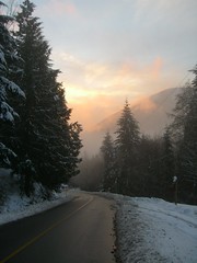
Ambrose comes through with a lovely set of photos of this week's snowy weather. All the man needs now is a blog...*hint hint*
Subscribe to:
Posts (Atom)

